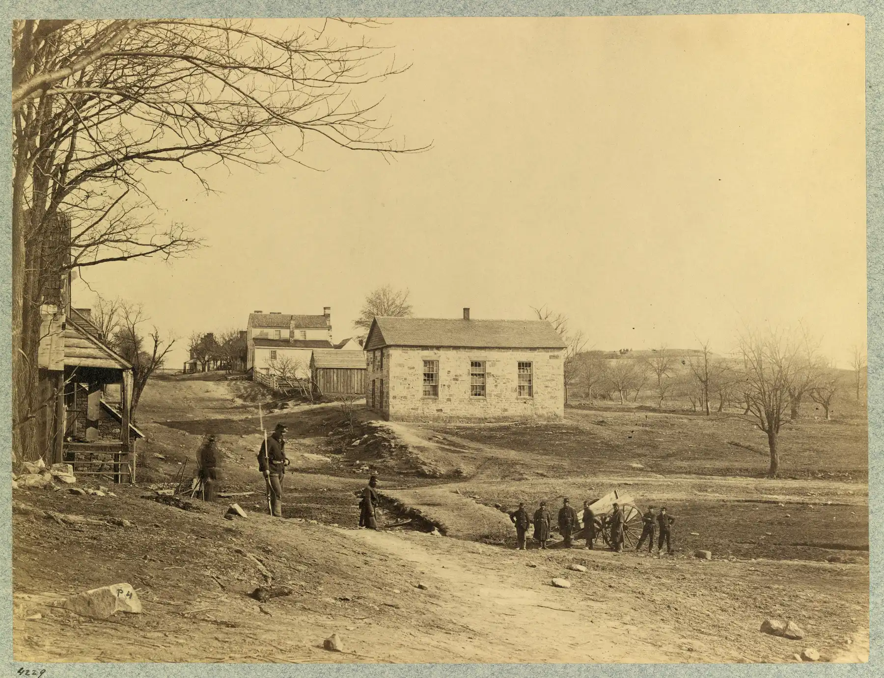
Centreville began as the village of Newgate and became a town by act of the Virginia Assembly in 1792. Mount Gilead, the Stone Church and Civil War earthworks.
Last checked Oct. 19, 2026. Facts come from Fairfax County’s Historic Centreville Park and Centreville Historic Overlay District pages, the county’s 1984 Centreville Historic District report (PDF) and the National Park Service.
Centreville is a suburb of more than 70,000 people today, but it began as a crossroads village on the old road west. “Centreville got its name because of its central location, where many roads came together,” the Fairfax County Park Authority says.
Who to call
- Historic Centreville Park: Fairfax County Park Authority, 703-324-8700, weekdays 8 a.m. to 4:30 p.m.
- Centreville Historic Overlay District and its review board: Department of Planning and Development, 703-324-1380
- Manassas National Battlefield Park: National Park Service, 703-361-1339
- Centreville Day and local history events: Friends of Historic Centreville
From Newgate to Centreville
The county’s 1984 report traces recorded history in the area to the early 1700s. Its oldest artifact is a boundary stone from the Willoughby Newton property marked “WN” and dated 1739. Tobacco was rolled to river ports along what became Braddock Road. By 1768 a tavern called Newgate stood on the road, and by 1773 Newgate was the name of the village itself.
In 1792 the Virginia Assembly, petitioned by the residents, “created the town of Centerville (though the name quickly altered to Centreville),” the report says. The town had tanneries and mills, and it was a trading center for the yearly hiring out of enslaved people each January, the report notes. An 1835 gazetteer it quotes counted about 30 houses, two taverns, three stores, a school and 220 people. Prosperity faded as the Little River Turnpike (finished in 1806) and, in the 1850s, the railroads bypassed the town.
The Civil War
Centreville’s ridge and roads put it at the center of the war in Northern Virginia, according to the county report:
- In April 1861 Centreville’s voters cast 105 votes for secession, a unanimous result.
- After the First Battle of Bull Run (Manassas) in July 1861, buildings in town served as hospitals.
- From October 1861, Confederate Gen. Joseph E. Johnston wintered nearly 40,000 men here. They built more than five miles of earthworks on the Centreville plateau and 1,500 log cabins by the end of December, and Johnston used Mount Gilead as his headquarters.
- The Confederates left March 8 and 9, 1862, and Union troops entered March 10. Photos from that spring, like the one above, show a town stripped of trees.
“The war devastated the whole town,” the Park Authority says, and the community struggled for years to recover. The paving of Lee Highway (today’s Route 29) after World War I began its turn into a commuter suburb.
Landmarks you can see
The Centreville Historic Overlay District, proposed in the county’s September 1984 report, protects old-town Centreville around Braddock Road, Mount Gilead Road and Wharton Lane. The report describes its core buildings:
| Landmark | Where | Date, as the county gives it |
|---|---|---|
| Mount Gilead | Mount Gilead Road, east of Route 28 | Built before 1750, per the 1984 report; about 1785, per the Park Authority. Once an inn; Johnston’s headquarters in 1861-62 |
| St. John’s Episcopal Church | Mount Gilead Road | Gothic Revival church with a churchyard cemetery; parish hall added in 1954 |
| Harrison House | Braddock and Mount Gilead roads | About 1840 |
| Havener House | Braddock Road | Standing by the Civil War; an inn, a wartime aid station and, around 1912, the post office |
| Centreville Methodist Church (the Stone Church) | Braddock Road | First built 1855 and used as a hospital; destroyed in the Second Battle of Manassas; rebuilt 1870, with a stone addition in 1945 |
| Spindle Sears House | Historic Centreville Park | A Sears, Roebuck “Brentwood” kit home built in 1935 |
Confederate earthworks survive on both sides of Wharton Lane, near St. John’s and on the Mount Gilead grounds, the 1984 report says. The Park Authority points visitors to 10 other historic buildings and features around the district.
Historic Centreville Park
At Historic Centreville Park you can see Mount Gilead House and the Spindle Sears House from the outside and walk through Civil War fortifications and the Covered Way. The park tells Centreville’s story in three eras: the road west (1785 to 1850), the war (1861 to 1865) and the road to the modern suburb (1917 to 1937).
National Register listings nearby
No property inside Centreville’s Census boundary appears in the National Park Service’s National Register of Historic Places map data. The nearest listings, with the year each was listed:
| Listing | Where | Listed |
|---|---|---|
| Manassas National Battlefield Park | Northwest of Manassas, Prince William County | 1966 |
| Sully | North of Route 28 and Route 50, Chantilly | 1970 |
| Clifton Historic District | Town of Clifton | 1985 |
| “A” Fort and Battery Hill Redoubt, Camp Early | Off Balmoral Greens Avenue, Fairfax County, near Manassas Park | 1998 |
Manassas National Battlefield Park, 6511 Sudley Road, preserves the fields of the First Battle of Bull Run on July 21, 1861, and the Second Battle in August 1862. It is open daily from dawn to dusk, with no entrance fee listed by the National Park Service.
Related guides
- Parks and trails in Centreville
- Building permits in the historic district
- Centreville population and growth
Frequently asked questions
When was Centreville, Virginia founded?
In 1792, when the Virginia Assembly created the town of Centerville, soon spelled Centreville, at the request of residents of the village then called Newgate, according to Fairfax County’s 1984 historic district report.
Why is it called Centreville?
For its central location. Fairfax County says many roads came together there, and an 1835 gazetteer quoted by the county said it was about equidistant from Leesburg, Middleburg, Warrenton, Washington, Georgetown and Alexandria.
Is Centreville on the National Register of Historic Places?
No place inside Centreville’s Census boundary appears in the National Park Service’s National Register map data. Old Centreville is protected locally as a Fairfax County Historic Overlay District. Nearby listings include Manassas National Battlefield Park (1966) and Sully (1970).
Where can I see Centreville’s Civil War history?
At Historic Centreville Park on Mount Gilead Road, where the Park Authority says visitors can walk through Civil War fortifications and the Covered Way, and at Manassas National Battlefield Park, open daily dawn to dusk.
Have your say